
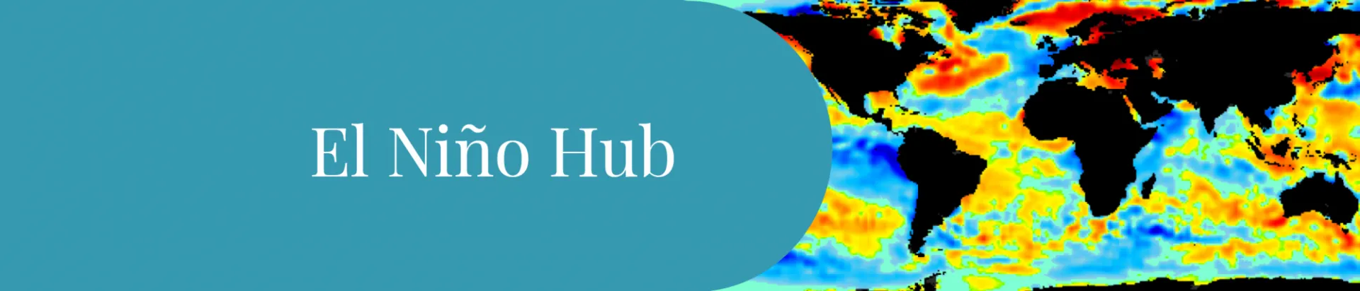
A very strong El Niño is here. Explore its impacts and what it means for weather, climate change, and communities worldwide.
Ocean surface temperatures in the central and eastern Pacific are currently 2.2°C warmer than normal — a sign of a “very strong” El Niño. Forecasters say there’s more than an 80% chance these conditions will persist through the end of the year, making it one of the strongest El Niños on record.
El Niño Quick Facts
El Niño is a natural climate pattern in which the surface of the of the central and eastern equatorial Pacific Ocean warms significantly. That warmth fuels storms over a huge stretch of ocean, and the heat and moisture those storms pump high into the atmosphere set off waves that propagate around the planet — shifting where storms form, how much it rains, and how warm it gets in places thousands of miles away.
Some Examples:
Drier and drought-prone: Southern Africa and Indonesia face a higher risk of drought and elevated fire risk.
Weaker monsoons: India’s monsoon rains are more likely to fail, potentially dropping more than 40% below normal.
Wetter than usual: Kenya, eastern China, and the southern U.S. tend to see increased rainfall.
The likelihood of these effects increases with the size and scope of the El Niño. For October–December 2026, forecasts show a more than 70% chance of above-normal rainfall in the southeastern U.S., and a more than 70% chance of below-normal rainfall in Indonesia.
Oceans absorb much of the extra heat trapped by greenhouse gases. During El Niño, the warm Pacific Ocean surface releases that stored heat into the atmosphere, often pushing global average temperatures to new highs. The last two El Niño events, in 2015 and 2023, each produced the hottest year on record at the time — and temperatures stayed elevated afterward, making 2016 and 2024 even warmer still.
Higher global temperatures bring more than a warmer average day: more frequent and intense heat waves, greater drought and wildfire risk, and heavier, more frequent storms. These shifts touch nearly every part of society — agriculture, energy and water security, ecosystems, supply chains, financial markets, travel, and health.
The time to prepare is now! Because the forecast El Niño event is highly certain, governments, businesses, and communities have a rare window to prepare before the impacts hit. Now is the time to assess resilience, review emergency resources, and close gaps in readiness. Climate and weather are likely to be highly disruptive in the coming year — now is the time to get ready.










Columbia CCSR/IRI ENSO Forecast
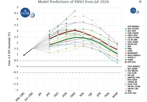
View a monthly summary of the status of El Niño and La Niña produced by the ENSO forecast team at our Center for Climate Systems Research / International Research Institute for Climate & Society.
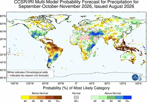
View seasonal climate forecasts for upcoming 3-month periods generated by the ENSO forecast team at our Center for Climate Systems Research / International Research Institute for Climate & Society.
Further Resources to Track El Niño
World Meteorological Organization El Niño/La Niña Updates - This update is prepared through a collaborative effort between WMO and the International Research Institute for Climate & Society, with contributions from experts worldwide.
El Niño Briefing 2026-2027 from NCDP
Unlike the hazards that arrive with little notice, a developing El Niño announces itself months ahead — and that lead time provides time for early action. Jeff Schlegelmilch and Andrew Kruczkiewicz of the National Center for Disaster Preparedness explain what we are worried about and what we can do about it.
Read: El Niño Is Here. Here’s Why That’s a Head Start, Not Just a Headline.
Featured El Niño Stories from State of the Planet
Climate Models Show El Niño Is Rapidly Strengthening
The World Meteorological Organization says a strong El Niño could drive extreme weather in many regions.
You Asked: What Exactly Is a ‘Super’ El Niño?
Columbia Climate School experts explain what a strong El Niño could mean for the planet this year.
Indonesia May Soon Lose Its Last Glaciers
Scientists estimate that Indonesia will lose its two remaining glaciers by 2030—a warning for glaciers around the world.
In The Media
‘Super’ El Niño Is Now a Near Certainty. Here Are 5 Side Effects You May Not Know About
We Are Not Ready for El Niño — Here’s How We Can Be
How the Super El Niño Could Turbocharge Warming in the Himalayas
El Niño-Southern Oscillation (ENSO) Deeper Dive
The El Niño-Southern Oscillation (ENSO) is one of the planet’s most important sources of year-to-year climate variability. It is a naturally occurring pattern of interactions between the tropical Pacific Ocean and atmosphere that influences temperature, rainfall, winds and storm tracks around the world through atmospheric "teleconnections."
Floods, droughts, heat waves, wildfires and other weather extremes occur during El Niño, La Niña and neutral years alike. What makes ENSO important is not that it creates these events, but that it changes the likelihood of certain climate patterns developing in different parts of the world. Because scientists can often detect the start of El Niño or La Niña months in advance, seasonal forecasts can help governments, businesses and communities prepare for any elevated climate risks before they occur.
El Niño and La Niña events typically develop over several months and can last for a year or longer. Their influence on seasonal temperature and precipitation patterns can therefore persist across multiple seasons, affecting agriculture, water resources, public health, ecosystems, energy production and disaster preparedness around the world.
The most direct effects of ENSO on regional climate patterns are found in regions closest to the tropical Pacific. During neutral conditions, Indonesia and other areas in the western Pacific experience more precipitation than in the eastern Pacific, such as Peru and Ecuador. However, during El Niño events, warmer surface waters in the tropical Pacific move eastward because of weakened trade winds. This leads to areas of low pressure and increased rainfall along the west coasts of North and South America.
Conversely, waters in the western Pacific become cooler than normal, which leads to higher pressure and decreased rainfall there. Although many regions of the world can experience disasters in any year, certain locations tend to be particularly hard hit during El Nino events. For example, effects from past El Niño events include flooding and landslides in Peru and California (including an estimated $2 billion in property damage in Peru during the 1997-98 event); forest fires and resulting air pollution in Indonesia; and droughts in northern Australia.
During neutral and La Niña conditions, the upwelling of cold and nutrient-rich water from the deep Pacific supports fisheries along the coast of equatorial South America. When El Niño conditions occur, warmer water off of equatorial South America and weaker trade winds reduce the usual upwelling, reducing the amount of available nutrients. The lack of nutrients affects marine life throughout the food chain, resulting in severe impacts to the Peruvian fisheries. In 1972, due to a combination of overfishing and El Niño, the Peruvian anchoveta fishery collapsed. The 1997-98 El Niño also adversely affected the Peruvian fisheries and economy. Strong El Niño events have also been associated with marine heatwaves and coral bleaching in some parts of the tropical Pacific.
During La Niña events, the trade winds strengthen, which increases equatorial upwelling and extends the colder water of the east Pacific westward. The resulting effects are essentially the reverse of El Niño: the western Pacific experiences higher than average precipitation, and the flooding that results can be severe, particularly following extended drought associated with El Niño. Lower than average temperature and rainfall occurs along the western coast of the Americas, while parts of northern Australia can experience more frequent tropical cyclones.
Yes! Although the strongest signal of ENSO impacts is in the areas closest to the equatorial Pacific, El Niño and La Niña are such powerful forces that they can shift seasonal temperature and precipitation patterns around the globe. These shifts, known as atmospheric teleconnections, occur via the effects of tropical sea-surface temperatures on the upper atmosphere. When different parts of the tropical ocean warm and cool and the pressure gradients shift, the atmospheric wind patterns also shift, altering precipitation patterns. Strong tropical rainfall releases significant heat in the atmosphere, which can influence large-scale atmospheric circulation. The shift in the location and intensity of tropical rainfall patterns results in shifts in the location and intensity of the jet stream and storm tracks, tropical cyclones and more. Because each El Niño and La Niña event has unique characteristics of timing, intensity and specific pattern ocean warming, such shifts are never exactly the same from one El Niño and La Niña to another. In addition, the atmospheric effects due to changes in sea-surface temperatures are responsible for only part of the regional climate that is observed; chaotic fluctuations within the atmosphere and sea surface temperatures in other areas of the globe also influence the weather and climate we experience. Because of this, anticipated ENSO impacts in seasonal forecasts are treated probabilistically and not with absolute certainty.
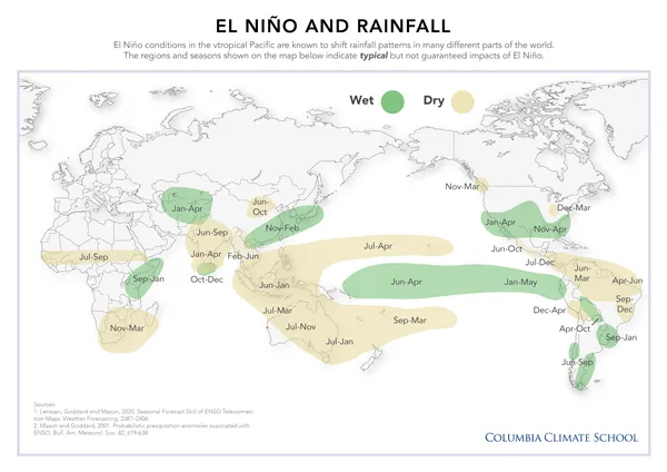
During the two strongest El Niño events of the twentieth century (1982-1983 and 1997-1998), the global impacts of altered climate patterns extended to disease outbreaks, natural disasters, limited water availability, disruption to hydropower generation, and animal migration. More recently, the 2015-16 and 2023-24 El Niño events also highlighted the broad global reach of ENSO, including record global temperatures, widespread coral bleaching and climate impacts across multiple continents. ENSO impacts during these years were not necessarily more disastrous than climate and weather events in years lacking an influence from ENSO. The difference is that the ENSO impacts can be related to a specific and predictable climate phenomenon, whereas for many climate and weather events, scientists cannot trace the cause of an event to such a phenomenon.
Among the effects of past ENSO teleconnections are the brown locust outbreak in southern Africa, which have been associated with early winter rainfall. Such early rainfall can also lead to drought, crop failure and famine. Such early rainfall can also lead to flooding in some areas, while in others, changing rainfall patterns may contribute to drought, crop failure and famine. During El Niño years, western Florida is more likely to experience above-average precipitation, which can increase water runoff and groundwater discharge during heavy rainfall. On the other hand, El Niño also tends to reduce the number of Atlantic hurricanes, and winter in the northern U.S. is often milder than average. Finally, La Niña years can bring more frequent and more damaging hurricanes to the western Atlantic Ocean.
At any given time, many processes are ongoing in the atmosphere, on land and in oceans all over the world. It is difficult to determine exactly which climate and weather events are a result of El Niño or La Niña and which are driven by other natural sources of climate variability. ENSO is a strong force, however, and in many areas it is the most dominant influence on seasonal climate patterns.
Because of this natural variability, scientists cannot guarantee particular outcomes. Instead, ENSO forecasts describe changes in the likelihood of different climate conditions. Even so, seasonal climate forecasts can provide valuable guidance several months in advance.
El Niño is a naturally occurring climate pattern that has existed for thousands of years. Climate change does not cause El Niño. However, because the planet is warmer than it was in the past, El Niño events now occur against a warmer global background. This means many El Niño-related impacts, including global average temperatures, marine heatwaves and some extreme rainfall events, can be amplified by long-term warming. Scientists continue to study whether climate change will alter the frequency or intensity of El Niño events, but there is not yet consensus on exactly how ENSO itself will change.
Climatologists and decision makers can anticipate future ENSO impacts by studying past events. Although forecasting involves uncertainty, the seasonal climate effects in some regions tend to shift in particular ways, making some outcomes more likely than others. For example, tropical regions are often affected more strongly by ENSO, and while they may face a higher risk of certain hazards, they may also be better able to anticipate these hazards and prepare for them.
Additionally, when favorable conditions are predicted for an upcoming season, decision makers can capitalize on the forecast. Farmers, for example, can plan for a good season by planting additional or different crops, or by buying fertilizer to further increase their yield. A farmer may be less likely to make these investments in a bad year, but if they know conditions are likely to be favorable, these investments can pay off.
An area's vulnerability to climate risks is also informed by its unique sociopolitical and economic characteristics. For example, a country in peacetime with developed infrastructure, highly organized emergency management, irrigated agriculture and a well-informed population will be well equipped to respond to fires, floods, droughts or crop failures, even if it is in a climate-vulnerable region. On the other hand, a country with fewer resources may be more vulnerable to climate risks, even if it is in an area that typically sees fewer climate hazards. Preparing for the effects of ENSO therefore requires understanding the geography, vulnerability and culture of a given area.
Responding and adapting to climate risks requires significant organization. While the best time to create preparedness plans for ENSO is before an event develops, this may be challenging in many areas. The Climate School and its centers provide a number of forecast tools and decision-support resources, as well as on-site training for users with different skills and capabilities. Leaders and decision makers across sectors—including disaster management, public health, agriculture and water resources—can cooperate and communicate to ensure that resources are shared, information is up to date and accurate, and responses are equitable for all stakeholders. Finally, the media can play an important role in communicating climate risks by providing accurate, science-based information to the public.
El Niño Fundamentals
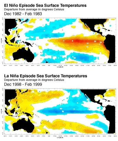
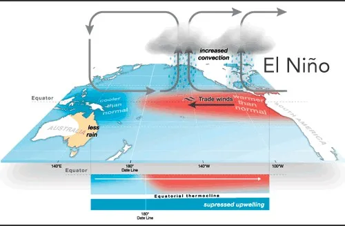
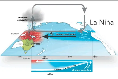
The El Niño-Southern Oscillation (ENSO) is one of the most important and longest-studied climate phenomena on the planet. It can lead to large-scale changes in sea-level pressures, sea-surface temperatures, precipitation and winds–not only in the tropics but across many other regions of the world. ENSO describes the natural year-to-year variations in the ocean and atmosphere in the tropical Pacific. Sea-surface temperatures in the central and eastern equatorial Pacific cycle between above- and below-average. An El Niño state occurs when the central and eastern equatorial Pacific sea-surface temperatures are substantially warmer than usual (see figure below, top). La Niña conditions occur when the central and eastern equatorial Pacific waters are substantially cooler than usual (see figure bellow, bottom). A La Niña event usually, although not always, follows an El Niño event.
El Niño refers to the ocean component of ENSO. Before scientists began studying ENSO in the twentieth century, Peruvian fishermen observed warmer ocean waters off the South American coast and the impact these warmer waters had on their fisheries. They named the phenomenon El Niño ("the boy child") because the effects were often most apparent during the Christmas season. The "Southern Oscillation" refers to the atmospheric component of ENSO: the shifting of atmospheric pressure between the central/eastern Pacific and the western Pacific.
Several years of neutral (or average) conditions can persist between La Niña and El Niño events. In order to understand the ENSO cycle, we must first understand what the Pacific is like in its neutral state.
The equatorial Pacific climate acts as a “coupled system” because the state of the ocean and atmosphere depend on each other. As the conditions of the ocean change, the atmosphere responds, and vice versa. The main indicators of these changes are pressure and temperature.
Air Pressure
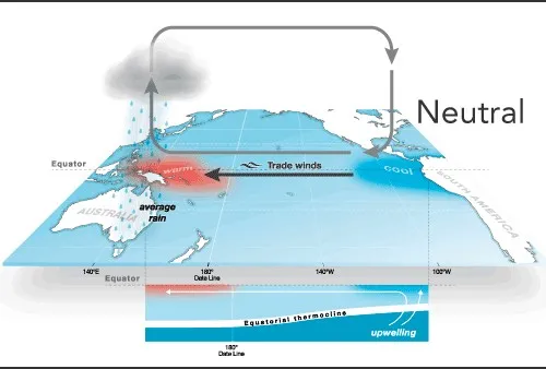
During neutral years (and on average) atmospheric pressure is low in the warmer western tropical Pacific (referenced at Darwin, Australia), and relatively higher in the cooler central/eastern tropical Pacific (referenced at Tahiti). Air naturally moves from areas of high pressure to low pressure, so this difference in pressure moves the equatorial air, known as the trade winds, from the coast of South America toward the western Pacific Ocean.
Ocean Temperatures
The sun heats water at the surface of the ocean, but the trade winds push surface water by friction from east to west in the Pacific. Cold water from below moves up to replace the shifted surface water in a process referred to as upwelling. During neutral conditions, waters in the eastern Pacific are upwelled along the equator and the coast of South America. Because the upwelled equatorial and coastal waters originate deep below the surface, they are cold and rich with nutrients. When the surface water arrives in the western Pacific, land surfaces restrict its further movement and so the water “piles up”, making sea level approximately half a meter higher around Indonesia than it is off the coast of Ecuador. As the water accumulates and stagnates, it continues to warm.
The Coupled System
Because low-level winds move toward warm surface waters in the tropics, the difference in sea-surface temperatures (SSTs) between the cooler eastern Pacific and warmer western Pacific reinforces the easterly trade winds during neutral conditions. This east-west SST gradient induces strong easterly winds, which force water to the west and cause greater upwelling of colder water in the east. The cold upwelled waters also increase the east-west SST gradient, again reinforcing the strong easterly trade winds across the Pacific. The ocean and the atmosphere thus create a coupled system that continues this process until it is disrupted.
Disturbances to the ocean that cause changes in the main temperature patterns affect the winds in this coupled system, which can lead to a positive feedback loop. During El Niño, this loop often begins with weakened, or sometimes even reversed, trade winds. The cause of these weakened winds is not always apparent, but depending on their strength and duration, they may trigger Kelvin waves. These waves travel eastward beneath the ocean surface, carrying warmer water across the equatorial Pacific. Sometimes this warmer water reaches the surface, forming a "tongue" of warm water—typically 1–3°C warmer than average—that stretches across the equatorial Pacific.
The warmer waters lower air pressure across the central and eastern Pacific, weakening the pressure gradient that normally drives the trade winds from east to west. The weaker trade winds reduce the westward movement of warm surface water, allowing warm conditions to persist and reinforcing the weakened pressure gradient. This positive feedback can sustain El Niño conditions for a year or longer.
The direct effects of these changes in ocean temperatures and atmospheric circulation often include increased rainfall along the west coast of the Americas and decreased rainfall across Indonesia, Australia and parts of Southeast Asia.
La Niña occurs as an enhanced version of the neutral state. When air pressure is higher than average in Tahiti and lower than average in Australia, the easterly trade winds become stronger than usual. Colder-than-normal ocean water extends across the eastern and central equatorial Pacific, while the stronger winds continue to push warm surface water westward, increasing sea level around Indonesia. The warmer waters in the western Pacific enhance rainfall across the region.
Because of the societal implications of announcing a developing El Niño or La Niña event, measurements must be accurate and carefully verified. One important indicator is the Southern Oscillation Index (SOI), which is calculated using the air pressure difference between Tahiti and Darwin. The SOI is typically negative during El Niño conditions and positive during La Niña conditions. Because short-term pressure changes can reflect local weather rather than ENSO, scientists generally average the measurements over several months to identify sustained changes associated with an event.
Another key source of observations is the Tropical Atmosphere Ocean (TAO) Array, a network of moored buoys maintained across the equatorial Pacific. The buoys measure and transmit sea-surface and subsurface temperatures, atmospheric conditions, ocean currents and wind data in near real time, providing scientists around the world with critical information for monitoring ENSO.
Today, these observations are also complemented by satellites, autonomous ocean instruments and computer models that together provide a more complete picture of conditions across the tropical Pacific.
The tropical Pacific is divided into several monitoring regions, each of which provides different information about ENSO. For example, the Niño 1+2 region often experiences the earliest warming during an El Niño event, the Niño 3 region exhibits some of the largest temperature variability, and Niño 4 is closely linked to rainfall patterns over Indonesia. The Niño 3.4 region best captures the large-scale ocean-atmosphere changes associated with ENSO and is therefore the primary region used by many forecast centers to monitor and predict El Niño and La Niña.
Scientists monitor both oceanic and atmospheric conditions across the tropical Pacific, tracking how sea-surface temperatures and atmospheric pressure deviate from average and how long those departures persist.
The exact criteria used to declare an El Niño or La Niña event vary somewhat among forecasting centers around the world, and some definitions incorporate both oceanic and atmospheric conditions.
In the United States, NOAA defines an El Niño (or La Niña) event using the Oceanic Niño Index (ONI), based on sea-surface temperatures in the Niño 3.4 region. An event is declared when the three-month average sea-surface temperature anomaly is at least ±0.5°C above or below average for five consecutive overlapping three-month periods. Other forecasting centers may use slightly different thresholds or additional indicators, but all are designed to identify sustained, basin-wide changes in the tropical Pacific.