Is the Hudson a River or an Estuary?
Each of us has a water address. No matter where you reside on land, you are a part of a watershed. A watershed is a geographic area whose rainfall, snowmelt, streams, and rivers all flow or drain into a common body of water, such as an ocean, lake, river, stream, estuary, or reservoir. Ultimately, most watersheds eventually drain into the ocean.
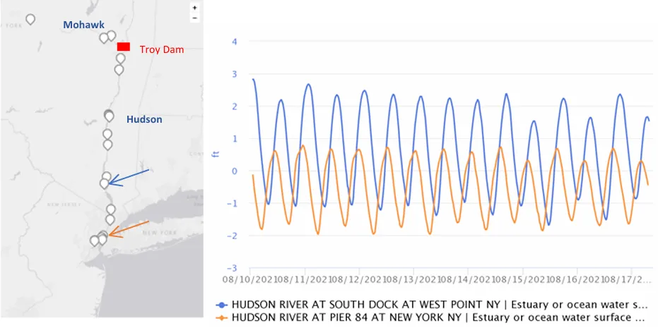
The Lamont-Doherty Earth Observatory’s Field Station is a part of the Hudson River watershed, one of particular importance as it expands across approximately a third of New York State and even into New Jersey, Vermont, Massachusetts and Connecticut! The freshwater input of the Hudson River starts at any location within the watershed. One drop of rainwater in the watershed could contribute towards the freshwater of the Hudson River, eventually draining into the Atlantic Ocean. The highest point of our watershed is at Mount Marcy in the Adirondacks. While the entire Hudson River spans an impressive 315 miles from Lake Tear of the Clouds to the Atlantic Ocean, our investigation will focus on the 153 miles stretch between the Troy Dam and the Atlantic Ocean.
In three activities, students investigate whether this section of the Hudson is an estuary or a river using the principles outlined by the National Oceanic and Atmospheric Administration (NOAA). They use fish species diversity, salinity ranges, and water level change to help in their investigation.